EWS4All — Impact-Based Forecasting

Multi-Hazard IbF Early Warning Aligned with UN EWS Initiative 2027

IES and HYDS deliver Impact-based Multi-Hazard Early Warning Systems (MH-IbF-EWS) — a complete solution combining web-based forecasting workstations with real-time alerting to protect communities from weather-induced disasters.

2027 UN Target Year
|

Due to Climate Change, disasters caused by weather-related events are expected to intensify. The United Nations is working to have Early Warning Systems in every country by 2027. IES and HYDS are ready to help nations meet this critical goal.

Our Proposed Solution

What is EWS4All?

IES, a Montreal-based pioneer with over four decades of experience in software development for Meteorology, Hydrology, Environment and Remote Sensing, has integrated a web-based Weather Forecasting System for Weather and Aviation Services — and extended it into a full Multi-Hazard Early Warning System in collaboration with HYDS of Spain.

Our group — IES and HYDS — brings extensive experience in all aspects of meteorology and hydrology, including the implementation of the A4EU project and the development of web-based Forecasting Workstations. This depth of experience in implementing comprehensive warning systems is ample.

Countries including Spain, Ireland, Andorra and Sri Lanka have already deployed systems based on Impact-based Forecasting Technology and timely alerting paradigms. IES and HYDS are positioned to bring this capability to any nation.

The EWS4All Solution Package
  • IES Met-WebGIS — Impact-based Forecasting Workstation
  • IES Met-WebGIS / WAFS — Aviation Weather Services
  • HYDS ARGOS — Multi-Hazard Early Warning System (MHEWS)

International Reach

Operational in Europe, Latin America, the Pacific and Africa

Proactive Alerting

Moves emergency management from reactive to proactive

System Architecture

The MH-IbF-EWS Pipeline

A complete Early Warning System integrates four essential components — from global model data to community-level warnings. IES and HYDS cover all four stages.

Stage 01
1
Global Forecast Models

Super-computer centres run global NWP models: NOAA, UK-Met, ECMWF, CMC and others — producing objective forecast data on a global basis.

Stage 02
2
National & Regional Models

Countries run their own downscaled models — DWD, Météo-France, ECCC and others — producing higher-resolution Objective Forecasting for their domain.

Stage 03 — IES
3
Subjective Analysis

Forecasters use IES Met-WebGIS to apply expertise to model outputs — integrating GRIB2, satellite, radar, OPMET, lightning, radiosonde and more into impact-based analysis.

Stage 04 — HYDS
4
Early Warning System

HYDS ARGOS performs Impact-based Forecasting, generating targeted alerts and warnings for communities, assets and infrastructure across multiple hazard types.

IES Met-WebGIS handles Stage 3 (Subjective Analysis) · HYDS ARGOS handles Stage 4 (MHEWS) · Together they deliver a complete MH-IbF-EWS solution.

40+
Years of Meteorological Software Experience
12+
Countries with IES Systems Deployed
2027
UN Target — EWS in Every Country
ISO
9001:2015 Certified Delivery
Solution Components

The Three-Part EWS4All System

Each component of EWS4All addresses a distinct layer of the warning chain — together they form a complete, end-to-end solution.

IES Software

Met-WebGIS
Impact-Based Forecasting

Met-WebGIS is the IES forecasting workstation — configured as a Decision Support System for Impact-based Forecasting. Fully developed and supported by IES with over 40 years of experience, it serves national meteorological organizations worldwide.

  • Fetching, processing and display of all meteorological products
  • GRIB2, alphanumeric, satellite and radar imagery management
  • Lightning data integration and display
  • Vertical and horizontal profiles, hodographs and tephigrams
  • Interactive 3D globe module for global navigation
  • 3DV-Cube for multi-dimensional atmospheric analysis
  • WIS 2.0 and IWXXM compliant data exchange
IES Software

WAFS-WebGIS
Aviation Weather Services

A SADIS-certified version of the IES WebGIS platform configured specifically for aviation weather assistance — delivering flight briefing, WAFS product display and OPMET data management via a standard web browser with no software installation required.

  • UK-Met SADIS FTP workstation certified
  • Interfaces with SADIS and ISCS WAFS sources
  • BUFR data decoded to reproduce SIGWX T4 charts
  • Flight Plan Module for pilot pre-flight briefing
  • TAF, METAR, SIGMET in TAC, XML and IWXXM
  • Vertical cross-section display along planned routes
  • Automated flight folder generation
HYDS Partner — Spain

HYDS ARGOS
Multi-Hazard Early Warning System

ARGOS was developed within the A4EU project framework — creating cutting-edge technology to enhance risk management of emergencies caused by weather-induced events. It provides solutions at continental, national and regional scales, already implemented in several European countries.

  • Hydrometeorological Forecasts
  • Impact-based Forecasting at community level
  • Exposure & Vulnerability assessment
  • Early Warning detection and trigger management
  • Dissemination of alerts to at-risk populations
  • Management Protocols for emergency response
  • Seamless harmonization across scales: continental, national, regional
IES WebGIS

Impact-Based Forecasting with Met-WebGIS

Met-WebGIS provides the Subjective Forecasting Workstation — the critical layer where an experienced forecaster's judgment transforms model outputs into actionable, impact-based products. The system integrates data from every available source into a single, web-based decision support environment.

Input for the workstation arrives in the form of model output (GRIB2 format), Alphanumeric OPMET data, Satellite Imagery, Radar Imagery, Radiosonde data and any other available data including Lightning, Microwave Radiometer Data and Wind Profiler data.

All generated products are web-enabled and accessible via any standard browser over Internet or LAN — with no proprietary software required at the end-user workstation.
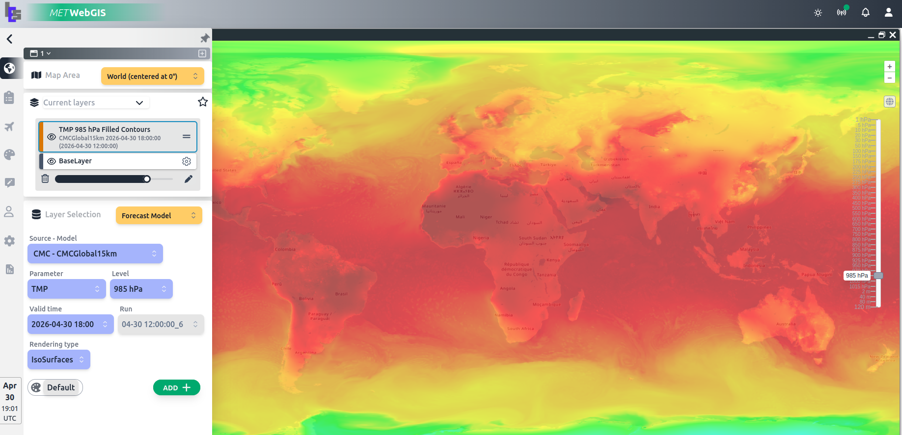
Met-WebGIS Impact-Based Forecasting
Application Domains

Met-WebGIS supports: Meteorology · Hydrology · Environment · Disaster Management · Road & Rail Transport · Energy Production · Crop Management · Pollution Monitoring · Air Transportation

HYDS ARGOS — Partner System

ARGOS: The Early Warning Layer

ARGOS helps organizations move the paradigm from reactive to proactive emergency management services. Developed within the A4EU project, it delivers cutting-edge technology for risk management of weather-induced emergencies at any scale.

The ARGOS platform is built around interconnected Central Node and National Node(s), enabling large-scale information sharing and highly localized warnings — including impacts and response protocols — in one integrated solution.

Droughts, floods, forest fires, air pollution, heat and cold waves, snowfalls — ARGOS covers every major hazard type, adapted to each region's specific risk profile and exposure.

1
Hydrometeorological Forecasts

Ingests and processes forecasts from national and regional NWP models to assess hydrometeorological conditions across the warning domain.

2
Impact-Based Forecasting

Translates meteorological conditions into expected impacts on people, property and infrastructure — the core of modern warning systems.

3
Exposure & Vulnerability

Combines hazard information with exposure and vulnerability data to quantify and map risk for communities and critical assets.

4
Early Warning Detection

Automated threshold monitoring and trigger management — detecting warning conditions and initiating the alert workflow in real time.

5
Dissemination of Alerts

Multi-channel alert dissemination to government authorities, media, aviation, marine users and the general public via web, mobile and WMO CAP standard.

6
Management Protocols

Structured emergency management protocols guide response activities — from initial alert through to all-clear — integrated directly into the ARGOS workflow.

Operational Scales

ARGOS Coverage — Every Scale

The ARGOS family of products enables seamless harmonization of emergency management across all operational scales — in a single integrated solution.

Continental

Pan-regional hazard monitoring and cross-border alert coordination

National

Country-wide warning management at the national meteorological service level

Regional

Province and state-level impact assessment with localized warning zones

Community

Argos City and Argos Site deliver impact-specific warnings at the community and asset level

Multi-Hazard Coverage

One System — Every Hazard

The MH-IbF-EWS solution covers all major weather-induced and environmental hazards — adapted to each country's specific risk profile and regional conditions.

Floods Droughts Forest Fires Air Pollution Heat Waves Cold Waves Heavy Snowfalls Severe Storms Flash Floods Storm Surge Landslides Dust Storms

Proven Deployment — Tonga Early Warning System

In 2024–2025, IES and HYDS won a World Bank project to deliver a fully Integrated Forecasting Platform (IES Met-WebGIS) and ARGOS-based Early Warning System for the Tonga Meteorological Service (TMS). Factory Acceptance Testing was completed in May 2025 and Site Acceptance Testing with user training was successfully completed by end of 2025.

Beyond weather services, the platform also strengthens national resilience by supporting the rapid dissemination of tsunami warnings and volcanic information, helping protect lives, infrastructure and livelihoods across the Tonga island group.

Solution Providers

IES Montréal, Canada
+
HYDS Spain

Our group — IES (Canada) and HYDS (Spain) — brings extensive combined experience in all aspects of meteorology, hydrology and impact-based forecasting, including the implementation of the A4EU project and the deployment of web-based Forecasting Workstations for national meteorological services around the world.

End-to-End Solution

How IES and HYDS Work Together

IES and HYDS deliver complementary, deeply integrated systems — covering the full chain from data ingestion to community-level impact alerting.

Forecasting Workstation

IES Met-WebGIS provides the forecaster with a complete decision support environment — integrating all data sources, rendering georeferenced products and enabling impact-based analysis using 2D and 3D tools.

Seamless Integration

Forecast outputs and impact assessments from Met-WebGIS feed directly into the ARGOS MHEWS — enabling the warning pipeline to operate as a single, coherent system from analysis to alert dissemination.

Community-Level Warnings

ARGOS translates forecast outputs into specific warnings tailored to communities, assets and infrastructure — including response protocols, exposure mapping and multi-channel alert delivery to authorities and the public.

Scalable Architecture

The combined IES + HYDS solution operates across all scales — from small island nations like Tonga to large continental countries — with configurable Central Node and National Node architectures to match any deployment context.

Multi-Channel Alerting

ARGOS disseminates warnings through government portals, broadcast media, mobile push notifications and WMO CAP-compliant feeds — ensuring alerts reach at-risk populations through every available channel.

ISO-Certified Delivery

IES delivers every project under its ISO 9001:2015-certified Quality Management System — including Factory Acceptance Testing (FAT), Site Acceptance Testing (SAT) and on-site user training for all EWS deployments.

EWS4All — IES & HYDS

Ready to Build Your Early Warning System?

Contact IES to discuss how our EWS4All solution — combining Met-WebGIS and HYDS ARGOS — can be deployed for your national meteorological service, civil protection agency or regional authority.

Back To Top